Master World Geography (Continents, Oceans, Important Countries) for SSC CGL
Get comprehensive theory, expert shortcuts, and hand-picked practice questions for World Geography (Continents, Oceans, Important Countries) specifically designed for the SSC CGL 2025-26 pattern.
World Geography: Continents, Oceans, Straits & Boundary Lines
World Geography forms a substantial part of the General Awareness section in the SSC CGL examination. High-yield topics include continent-wise landforms (deserts, peaks, rivers), oceanic features (deep-sea trenches and ocean currents), crucial maritime straits, and international boundary lines. This guide compiles essential theory, infographics, and 20 practice questions curated for the latest CGL standards.
Learning path
- Continents, Major Peaks & Deserts
- Oceans, Currents & Deep Trenches
- Global Straits, Canals & Boundaries
- 20 CGL-Pattern Solved Questions
1. Continents & Major Landforms
The Earth's landmass is divided into seven continents. Candidates must memorize the extreme points and major landforms of each:
Key Continental Records
| Continent | Highest Peak | Longest River | Major Desert |
|---|---|---|---|
| Asia | Mt. Everest (8,848m) | Yangtze (China) | Gobi / Arabian / Thar |
| Africa | Mt. Kilimanjaro (5,895m) | Nile (Longest in world) | Sahara (Largest hot desert) |
| North America | Denali / Mt. McKinley (6,190m) | Mississippi-Missouri | Mohave / Sonoran |
| South America | Mt. Aconcagua (6,961m) | Amazon (Largest by volume) | Atacama (Driest desert) |
| Europe | Mt. Elbrus (5,642m) | Volga | None (No deserts in Europe) |
| Australia / Oceania | Mt. Kosciuszko (2,228m) | Murray-Darling | Great Victoria / Gibson |
Prominent Mountain Ranges & Lakes
- Andes Mountains: Located in South America, it is the longest continental mountain range in the world (approx. 7,000 km).
- Rocky Mountains: The primary mountain range system in western North America.
- Atlas Mountains: Located in northwestern Africa, separating the Mediterranean coastline from the Sahara.
- Lake Baikal: Located in Siberia, Russia. It is the deepest lake in the world (1,642m) and contains about 20% of the world's unfrozen surface fresh water.
- Lake Superior: Located in North America. It is the largest freshwater lake in the world by surface area.
2. Oceans, Deep-Sea Trenches & Ocean Currents
Oceans cover approximately 71% of the Earth's surface. Ocean currents and deep-sea trenches are key variables in maritime geography:
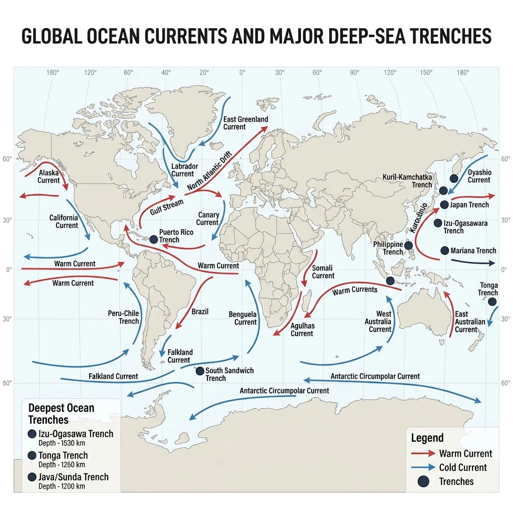
Deep-Sea Trenches
Trenches are steep depressions in the ocean floor created by tectonic subduction zones:
- Mariana Trench: Located in the Western Pacific Ocean. Its deepest point, Challenger Deep (~10,994m), is the deepest spot on Earth.
- Puerto Rico Trench: The deepest trench in the Atlantic Ocean (~8,376m).
- Sunda / Java Trench: The deepest trench in the Indian Ocean (~7,725m).
Ocean Currents
Currents are continuous, directed movements of ocean water driven by wind, Coriolis Effect, temperature, and salinity gradients:
- Warm Ocean Currents: Flow from equatorial regions towards the poles.
- Gulf Stream (Atlantic): Extremely warm and swift current that regulates the climate of Western Europe.
- Kuroshio Current (Pacific): Also known as the Black Current, flows north of Taiwan and Japan.
- Brazilian Current (Atlantic), Agulhas Current (Indian).
- Cold Ocean Currents: Flow from polar regions towards lower latitudes.
- Labrador Current (Atlantic): Flows south from the Arctic Ocean, meeting the warm Gulf Stream to create dense fog zones (near Newfoundland).
- Humboldt / Peru Current (Pacific): Flows north along the western coast of South America; closely linked to the El Niño phenomenon.
- Canary Current (Atlantic), Benguela Current (Atlantic), California Current (Pacific).
3. Major Straits, Canals & Boundary Lines
Maritime choke points (straits and canals) and land-based geopolitical boundary lines are frequently targeted in SSC CGL exams:
Key Straits & Canals
- Strait of Gibraltar: Connects the Atlantic Ocean to the Mediterranean Sea. Separates Europe (Spain) from Africa (Morocco). Known as the "Key to the Mediterranean".
- Strait of Malacca: Connects the Andaman Sea (Indian Ocean) and the South China Sea (Pacific Ocean). Separates the Malay Peninsula and Sumatra (Indonesia). The busiest shipping channel in the world.
- Bab-el-Mandeb: Connects the Red Sea to the Gulf of Aden (Indian Ocean). Separates Asia (Yemen) from Africa (Djibouti/Eritrea). Known as the "Gate of Tears" due to navigational hazards.
- Suez Canal: An artificial sea-level waterway in Egypt. Connects the Mediterranean Sea directly to the Red Sea, eliminating the need to sail around Africa (Cape of Good Hope). Opened in 1869.
- Panama Canal: An artificial waterway connecting the Atlantic Ocean and Pacific Ocean through the Isthmus of Panama, utilizing a complex gravity lock system. Opened in 1914.
Important International Boundaries
- 49th Parallel: The boundary line between the United States of America and Canada (longest border between two countries).
- 38th Parallel: Geopolitical border line separating North Korea and South Korea.
- Durand Line: Boundary line separating Pakistan and Afghanistan (originally drawn to divide British India and Afghanistan).
- Radcliffe Line: Boundary line separating India and Pakistan (and formerly East Pakistan/Bangladesh), drawn in 1947.
- MacMahon Line: Boundary line separating Northeast India (Arunachal Pradesh) and Tibet/China.
4. Practice Questions (20 Premium Solved Questions)
Which of the following mountain ranges is the longest continental mountain range in the world, stretching over 7,000 kilometers?
Step-by-step Solution
Which river is the longest in the world, flowing northwards through northeastern Africa into the Mediterranean Sea?
Step-by-step Solution
Mariana Trench, the deepest trench on Earth with its lowest point at the Challenger Deep, is located in which ocean?
Step-by-step Solution
The Suez Canal, which was opened in 1869 in Egypt, connects which two major bodies of water?
Step-by-step Solution
Which boundary line separates the sovereign nations of North Korea and South Korea?
Step-by-step Solution
Which of the following is a cold ocean current flowing northwards along the western coast of South America?
Step-by-step Solution
Which strait connects the Atlantic Ocean to the Mediterranean Sea and separates Spain from Morocco?
Step-by-step Solution
The Durand Line forms the international border line between which two countries?
Step-by-step Solution
Which of the following is the deepest lake in the world, containing approximately 20% of the world's unfrozen surface fresh water?
Step-by-step Solution
The Strait of Malacca, which forms a vital maritime shipping channel, separates which two landmasses?
Step-by-step Solution
Which of the following deserts is known as the driest non-polar desert on Earth, receiving almost zero precipitation annually?
Step-by-step Solution
Which continent is the only one in the world that has no deserts?
Step-by-step Solution
The 49th Parallel forms the extensive international boundary line between which two countries?
Step-by-step Solution
Sunda Trench (formerly known as the Java Trench), the deepest point in the Indian Ocean, lies off the coast of which nation?
Step-by-step Solution
Which of the following straits connects the Red Sea to the Gulf of Aden and the Indian Ocean, separating Yemen from Djibouti?
Step-by-step Solution
Which cold ocean current originates in the Arctic Ocean and flows south, eventually meeting the warm Gulf Stream off the coast of Newfoundland?
Step-by-step Solution
Which is the largest freshwater lake in the world by surface area?
Step-by-step Solution
The MacMahon Line, which serves as a disputed boundary line, separates which two regions or countries?
Step-by-step Solution
Which is the smallest continent in the world by land area?
Step-by-step Solution
Which ocean current is warm, flows along the eastern coast of Japan, and is the Pacific equivalent of the Atlantic Gulf Stream?
Step-by-step Solution
Strategy errors to avoid
Conflating Atlantic vs. Pacific Currents
Always check the ocean basin. Gulf Stream and Labrador belong to the Atlantic Ocean. Kuroshio and Oyashio belong to the Pacific. CGL questions often swap ocean names to trip up candidates.
Canal Connection Details
Be precise with water body pairs. Suez Canal connects Mediterranean and Red Sea. Panama Canal connects Atlantic and Pacific Ocean. Do not confuse Suez with Kiel or Corinth canals.