Master Indian Geography (Rivers, Mountains, Climate) for SSC CGL
Get comprehensive theory, expert shortcuts, and hand-picked practice questions for Indian Geography (Rivers, Mountains, Climate) specifically designed for the SSC CGL 2025-26 pattern.
Indian Geography: Mountains & Passes, Rivers, Climate & Monsoon
Indian Geography is a high-scoring and critical component of the General Awareness section in SSC CGL. The syllabus extensively covers the physiographic divisions of India, major drainage basins, key mountain passes, and the complex mechanics of the Indian Monsoon. This comprehensive guide outlines high-yield theoretical concepts, geographical facts, and practice questions aligned with the latest exam pattern.
Learning path
- Himalayan & Peninsular Mountain Ranges
- Himalayan & Peninsular River Systems
- Climate Zones, Monsoons & Seasons
- 20 CGL-Pattern Practice Questions
1. Indian Mountain Systems & Key Passes
India can be divided into distinct physiographic units. The northern boundary is dominated by the Himalayas, while the peninsula hosts ancient block and fold mountains:
The Himalayan Ranges
The Himalayas are young fold mountains formed by the collision of the Indo-Australian and Eurasian tectonic plates, compressing the Tethys geosyncline. They consist of three parallel ranges:
- Greater Himalayas (Himadri): The loftiest and most continuous range, with an average height of 6,000m. Home to the world's highest peaks, including Mount Everest (8848.86m, Nepal) and Kanchenjunga (8586m, India).
- Lesser Himalayas (Himachal): Located south of the Himadri, with heights ranging between 3,700m and 4,500m. Contains prominent ranges like Pir Panjal (longest range), Dhauladhar, and Mahabharat. Famous hill stations (Shimla, Mussoorie, Nainital) are situated here.
- Outer Himalayas (Shiwaliks): The outermost range, composed of unconsolidated sediments. Average altitude is 900m to 1,100m. The valleys lying between the Himachal and Shiwaliks are known as Duns (e.g., Dehradun, Patli Dun).
- Trans-Himalayas: Lie immediately north of the Greater Himalayas. Includes the Karakoram (hosts K2 / Godwin Austen, 8611m, highest peak in India), Ladakh, and Zaskar ranges.
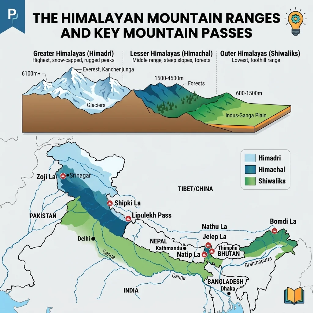
Key Mountain Passes (La)
Mountain passes are crucial routes across the rugged Himalayan ridges, heavily tested in CGL:
| Pass Name | Location (State/UT) | Connects / Significance |
|---|---|---|
| Zoji La | Ladakh | Connects Srinagar with Leh; historical lifeline. |
| Bara-Lacha La | Himachal Pradesh | Connects Lahaul district in HP to Leh in Ladakh. |
| Shipki La | Himachal Pradesh | Connects HP with Tibet; the Sutlej River enters India here. |
| Nathu La | Sikkim | Connects Sikkim with Tibet; old Silk Route branch. |
| Bomdi La | Arunachal Pradesh | Connects Arunachal Pradesh with Lhasa (Tibet). |
| Lipulekh | Uttarakhand | Connects Uttarakhand with Tibet; used by Kailash-Mansarovar pilgrims. |
Peninsular Mountains
- Aravalli Range: One of the oldest fold mountain systems in the world, now highly eroded as residual mountains. Highest peak is Guru Shikhar (1,722m, Mt. Abu, Rajasthan).
- Vindhyas and Satpuras: Block mountain systems in Central India. The Narmada River flows in a rift valley between the Vindhyas (north) and Satpuras (south). The Tapi River flows south of the Satpuras.
- Western Ghats (Sahyadris): A continuous escarpment forming the western edge of the Deccan Plateau. Highest peak is Anamudi (2,695m, Kerala), which is also the highest peak in South India. Meets the Eastern Ghats at the Nilgiri Hills (highest peak: Doddabetta, 2,637m).
- Eastern Ghats: Discontinuous, highly dissected hills running parallel to the east coast. Highest peak is Jindhagada Peak (1,690m, Andhra Pradesh), followed by Mahendragiri (1,501m, Odisha).
2. Drainage Systems of India
India's rivers are classified into two major groups based on their origin and water regime:
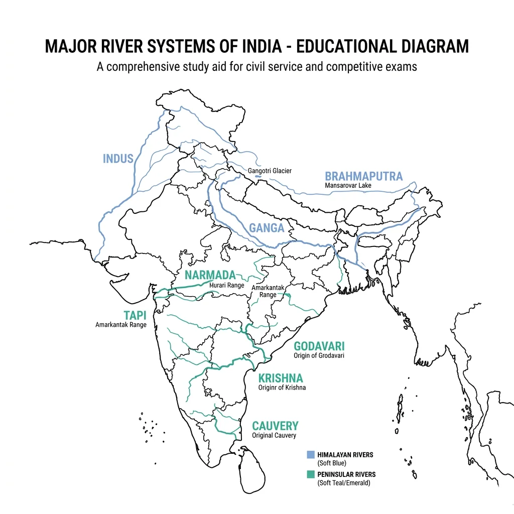
Himalayan River Systems
These are perennial rivers fed by both glacial melt and monsoon rainfall. The three main systems are:
- The Ganga System: Originates as Bhagirathi from Gangotri Glacier. Merges with Alaknanda at Devprayag to form the Ganga.
- Right-bank tributaries: Yamuna (originates at Yamunotri, joins Ganga at Prayagraj), Son, Punpun.
- Left-bank tributaries: Ramganga, Gomti, Ghaghara, Gandak, Kosi (known as the "Sorrow of Bihar"), Mahananda.
- The Indus System: Originates near Mansarovar Lake (Tibet). Flows northwest through Ladakh and enters Pakistan. Its five major Indian tributaries (Panjnad) are Jhelum, Chenab (largest tributary by volume), Ravi, Beas, and Sutlej.
- The Brahmaputra System: Originates near Chemayungdung Glacier (Tibet) where it is called Tsangpo. Enters India in Arunachal Pradesh as Dihang. In Bangladesh, it is known as Jamuna and joins the Ganga (Padma) to form the Sundarbans Delta (world's largest delta). Major tributaries include Subansiri, Teesta, Manas, Lohit, and Dhansiri. Hosts Majuli (world's largest river island) in Assam.
Peninsular River Systems
These are seasonal rivers reliant entirely on monsoon rain. They are divided by the water divide:
- East-Flowing (Drain into Bay of Bengal): They form extensive deltas at their mouths.
- Godavari: The longest peninsular river (1,465 km), known as Dakshin Ganga or Vriddha Ganga. Originates at Trimbakeshwar, Nashik (Maharashtra). Tributaries: Pemganga, Wainganga, Wardha, Manjira, Indravati, Sabari.
- Krishna: Originates near Mahabaleshwar (Maharashtra). Tributaries: Tungabhadra, Bhima, Koyna, Ghataprabha, Malaprabha, Musi.
- Cauvery: Originates at Talacauvery, Brahmagiri Hills (Karnataka). Known as the "Ganga of the South" due to its sacred nature. Tributaries: Kabini, Hemavati, Arkavati, Bhavani, Noyyal, Amravati.
- Mahanadi: Originates in Sihawa, Chhattisgarh. Noted for the Hirakud Dam (world's longest earthen dam).
- West-Flowing (Drain into Arabian Sea): They do not form deltas; instead, they form estuaries due to steep slopes and hard rock pathways.
- Narmada: Originates at Amarkantak Plateau (Madhya Pradesh). Flows through a marble rock gorge forming the Dhuandhar Falls near Jabalpur.
- Tapi (Tapti): Originates in Multai, Betul district (Madhya Pradesh). Parallel to Narmada.
- Luni: An ephemeral/inland river originating in the Aravalli range and disappearing into the Rann of Kutch (Gujarat).
3. Climate & The Monsoon System
India experiences a Tropical Monsoon type of climate. The climate is highly regulated by the unique layout of the Himalayas in the north (blocking cold Siberian winds) and the Indian Ocean in the south.
The Southwest Monsoon (June - September)
This is the primary rainy season, contributing over 75% of India's annual rainfall. It is triggered by the intense heating of the Tibetan Plateau during summer, creating a low-pressure area that draws moist winds from the high-pressure zone over the southern Indian Ocean.
- Arabian Sea Branch: Hits the Western Ghats first, causing heavy orographic rainfall on the windward side (e.g., Mumbai, Coastal Karnataka). It passes over Rajasthan without causing rain because the Aravalli Range lies parallel to the wind direction.
- Bay of Bengal Branch: Moves up the Bay of Bengal, hitting Northeast India. The funnel-shaped Khasi hills trap this moisture, causing extreme rainfall in Mawsynram (Cherrapunji, Meghalaya), which is the wettest place on Earth. It then deflects westward along the Ganga plains.
Northeast / Retreating Monsoon (October - November)
As temperatures drop in the north, high pressure develops over the land. The winds reverse, blowing from land to sea (northeast to southwest). These winds pick up moisture as they cross the Bay of Bengal and deposit rainfall on the Coromandel Coast (Tamil Nadu) during winter.
Important Climatic Concepts
- Western Disturbances: Shallow cyclonic depressions originating in the Mediterranean Sea that travel eastward via subtropical jet streams. They cause crucial winter rainfall in Punjab, Haryana, and snowfall in Jammu & Kashmir and Himachal Pradesh, which is highly beneficial for Rabi crops (especially wheat).
- El Niño and La Niña:
- El Niño: Unusually warm ocean currents in the equatorial eastern Pacific. Historically correlates with weak Indian Monsoons and drought conditions.
- La Niña: Cooling of equatorial eastern Pacific waters. Generally results in a strong, abundant monsoon and floods in India.
- Mango Showers: Pre-monsoon showers occurring in Kerala and Karnataka during late spring, helping in the early ripening of mangoes. Known as Kaal Baisakhi in West Bengal (characterized by destructive thunderstorms).
4. Practice Questions (20 Premium Solved Questions)
Which peak is the highest in the entire peninsular region of India and is also known as the highest peak in South India?
Step-by-step Solution
Which high-altitude Himalayan mountain pass connects the valley of Srinagar to Leh in Ladakh?
Step-by-step Solution
Which river is widely known as 'Dakshin Ganga' (or the Ganga of the South) due to its length and drainage basin size among peninsular rivers?
Step-by-step Solution
The Narmada River originates from which of the following highlands or plateaus?
Step-by-step Solution
Majuli, the world's largest inhabited riverine island, is situated on which river in the state of Assam?
Step-by-step Solution
The winter rainfall in the northwestern parts of India (Punjab, Haryana) is caused by which of the following meteorological phenomena?
Step-by-step Solution
Through which of the following states does the Tropic of Cancer (23.5° N) NOT pass?
Step-by-step Solution
The Loktak Lake, famous for its floating circular islands called 'Phumdis' and hosting the Keibul Lamjao National Park, is located in which state?
Step-by-step Solution
Which mountain range acts as a major water divide between the Indus River basin and the Ganga River basin?
Step-by-step Solution
Which Himalayan pass connects the state of Sikkim with the Tibet Autonomous Region of China, and was reopened in 2006 to resume bilateral border trade?
Step-by-step Solution
The Western Ghats and Eastern Ghats meet at which of the following mountain junctions?
Step-by-step Solution
Which wind system is primarily responsible for bringing heavy winter rainfall to the Coromandel Coast (Tamil Nadu)?
Step-by-step Solution
The river Sutlej enters India through which of the following mountain passes?
Step-by-step Solution
Which of the following peninsular rivers flows through a structural rift valley between the Vindhya and Satpura ranges?
Step-by-step Solution
Guru Shikhar, with an elevation of 1,722 meters, is the highest peak of which mountain range?
Step-by-step Solution
Which state in India possesses the longest coastline along the Arabian Sea/Indian Ocean?
Step-by-step Solution
What is the general impact of the meteorological phenomenon 'El Niño' on the Southwest Monsoon of India?
Step-by-step Solution
Which river forms the famous Dhuandhar Falls, where it cuts through spectacular white marble rocks near Jabalpur?
Step-by-step Solution
The outer-most, low-altitude range of the Himalayas, composed of unconsolidated sediments from main Himalayan rivers, is called the:
Step-by-step Solution
The Chenab River, which is the largest tributary of the Indus, is formed by the confluence of which two headwater streams in Himachal Pradesh?
Step-by-step Solution
Strategy errors to avoid
Conflating River Confluences
Do not mix up Devprayag and other Prayags (e.g., Rudraprayag, Karnaprayag). Devprayag is where Alaknanda and Bhagirathi merge to officially become the Ganga. Questions on confluences are highly frequent and easily confused.
East vs. West Flowing River Deltas
Remember that west-flowing rivers like Narmada and Tapi flow through hard rock terrains and steep gradients, forming estuaries, NOT deltas. East-flowing rivers like Godavari, Krishna, and Mahanadi form wide deltas.